How to discover a lost city from your couch
Part 2 - continued from this blog page
What are the different phases of the city, specific layout and when was it built?

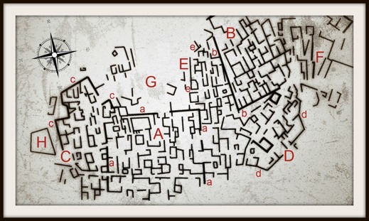
an expanding city The visible parts of the city seems to constitute six distinctive areas (A - F). All differing in orientation from one to the other. Area A makes a larger rectangular area in the centre, area B is yet another area of the same size but slightly tilted in a more northwest-southeast direction. Area C, more or less, follows the same direction as area B, and areas D & E seems to glue the gaps between the previous mentioned zones. Area F is lacking identifiable structures - at least for me. All these areas are more or less quite clear - but what comes next should be taken with a grain of salt. Use it merely as an example on how to deal with various building phases. This is just a general first approach - meant to be deconstructed, again and again.
I suggest the following. Before providing any dates of the various areas A-F, we can assume that area A was built first. The area is about 130x110 meters and sections of a defensive wall are clearly seen surrounding it (“a”). The city then probably expanded towards east (E), following the original orientation. Due to a geological feature, in a steep area in the southwestern part of the plan, the city could not keep its orientation when expanding south. This is why area D is changing direction but keeps extending the defensive walls "d".
The next addition is area B. It clearly represents a fundamental change of the original city plan. Not only does it cut area E, but it ads a defensive wall within the older city. This could be interpreted as the construction of a new citadel or a palace structure within the city or/and a new and separate fortification belonging to a subsequent period with a new focus on defence. The latter is a common phenomenon in later periods, since the last phases of a city usually represents the downfall of any given urban centre. The desperate extension of enforced protective walls indicates that the city needed it, but ultimately was destroyed or simply went out of use.
Area C, with its attached protective walls "c", is built parallel to area B and attached to area A. Since area C and B in fact are parallel to each other it suggests that the entire city, with all its various phases, was used until it was abandoned. The rather empty area G, might very well constitute a lack of walls and building material – used to reinforce areas B and C. But this is of course very hard to say.

what kind of buildings? As with many discernible and abandoned desert cities – we often find them in North Africa. So yes, this city was found somewhere in the region of Sahara. If we focus on area A, which also seems to represent the oldest part of the city, it very much resembles that of a smaller Roman castrum - a roman fort. The latter usually refers to an enclosure with buildings used as a military defensive position in Roman times. In this case we are talking about a castrum stativa - that is, a permanent camp with properly built houses as opposed to, for example, tents.
Judging from the visible structures, the castrum increased beyond its shielding walls into a small city and in this case becoming as large as half the size of the infamous city of Herculaneum (or 1/12 the size of Pompeii).
Other typical features of a castrum, such as a surrounding ditch, street layout, towers and other features, are however not clearly seen in the sand. We must not forget that the visible phase of walls merely represent the final layout of the city. We can assume that long time passed between the establishment of the castrum and that it was rebuilt and modified although keeping its original core and rigid defensive wall structure. One square-shaped and large building is still visible in the centre of area A (the building is visible on the satellite photo on the previous page). The building could perhaps represent a Late Roman praetorium?

a city, how old? Based on the region where the city was found and considering a Roman military camp that later developed into a smaller urban area, most likely commercial, we can assume that the city could be dated to the period from the early 2nd to the 6th century AD.
Remember that my assumptions can be completely wrong. An inspection of pottery and other scattered surface remains, would give us a better idea of what is hidden under the sand. In archaeological terms this is called a "survey". Staying in your couch is no longer an option ;)
Good luck exploring the deserts!
/Richard Holmgren, 2014

